TWONAV PREMIUM
5.99€ - iOS / Android
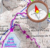
TwoNav Premium is an application developed for all hiking enthusiasts, whether on foot, by bike, or in a 4x4. It offers you the possibility to visualize a very large catalog of topographic maps, vector maps, or satellite images in 2D or 3D.
More than 60 data points can be displayed on the screen, including current speed, average speed, a stopwatch, and maximum altitude.
Once the hike is finished and you are back in your car, the application can serve as a road navigator.
Several maps are available through in-app purchases (IGN Geoportail 17.99€, IGN France 3.99€, etc.).